East Branch North River Fishing Spot
- Elevation: 1036'
- Last Modified By: vinny60 on 09/01/09 02:56 PM
- Ask about East Branch North River in our Fishing Forums
Photos
Fish Species
Comments
-
Have you fished at East Branch North River? Be the first to comment on this fishing spot.
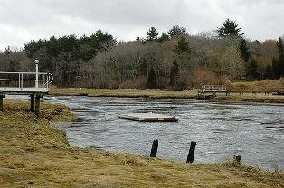
East Branch North River Description
The North River is a river, approximately 8 miles (13 km) long, in eastern Massachusetts, the United States. It is primarily a tidal river, formed by the confluence of the Indian Head River and Herring Brook. The North River forms the boundary between the towns of Norwell and Pembroke, Massachusetts, and downstream, the boundary between Scituate and Marshfield. The river flows into Massachusetts Bay. The North River is a great resource for Norwell and surrounding towns, including Scituate, Marshfield, Pembroke, and Hanover,...and always has been. It played an especially important part of Norwell's economic history, and now contributes as a recreational asset for great four-season recreation. Public access: Bridge Street / Union Street, Chittenden Lane (off River) from the shore. Or any boat, get in from these landings, or come up stream from Mary's on Rt 3A in Marshfield or King's Landing (off Main Street, 1/4 mile East of Harbor Lane)